Introduction
Geocoding is the process of converting locations such as street addresses or intersections to geographic coordinates
in order to place them on a map. For SWITRS records that are incorporated into TIMS, we assign coordinates that are
used for mapping based on the street descriptions and highway postmile information. These coordinates are available
in any of the raw data downloads as the POINT_X and POINT_Y fields.
The data downloads also contain LATITUDE and LONGITUDE fields which represents GPS coordinates
that are entered by the police officer reporting the crash, but they are only used to map data for a small percentage
of records that cannot be accurately geocoded.
Data Sources
A combination of data sources is used for geocoding the crashes. Streetmap Premium from ESRI is used for local roadways and data from the Transportation System Network (TSN) database by Caltrans is used for state highways. The California Road System (CRS) Maps developed by Caltrans is used for incorporating the functional classification into SWITRS records. More information about TSN and CRS Maps is available here.
Geocoding
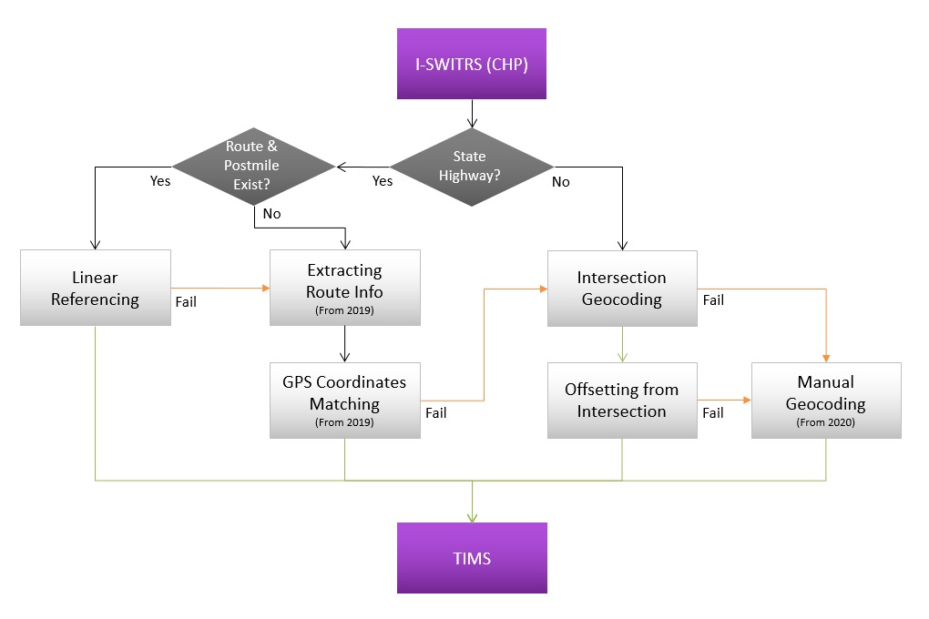
SafeTREC uses a multi-step process to perform SWITRS geocoding. The overall workflow is shown below and the subsequent sections outline the individual processes for geocoding state highway crashes, geocoding local roadway crashes, and assigning functional classification.
State Highway Crashes
SafeTREC geocodes state highway crashes through a process known as linear referencing which requires calculating the distance of a point from known location markers. In the case of state highways in California, the location markers are postmile values along each highway at intersections or on/off ramps. By comparing certain fields in SWITRS with the linear referencing system, crashes can be accurately geocoded on state highways. You can learn more about Postmiles and Linear Reference System at: Caltrans Postmile System (PDF).
Fields required by SafeTREC's geocoding process include
the ROUTE NUMBER, SIDE OF HIGHWAY, ROUTE SUFFIX, POSTMILE PREFIX, and POSTMILE fields.
All of these state highway related fields are input by Caltrans personnel into the SWITRS data separately from the initial report.
In late 2015 the California Highway Patrol (CHP) migrated to the California Collision Reporting System (CCRS) which enables an electronic submission to the SWITRS database.
In coordination with the new system, there is no mechanism for Caltrans to share the highway information back to SWITRS.
This means that the fields required for SafeTREC's state highway geocoding process were no longer included in SWITRS.
To overcome this limitation, SafeTREC developed an automated process of identifying the accuracy of GPS coordinates (LATITUDE and LONGITUDE fields) collected
and assigned each crash to the appropriate state highway. If a GPS coordinate is deemed inaccurate, then a final attempt
to geocode state highway crashes is made using the SafeTREC geocoding process for local roadway crashes.
Local Roadway Crashes
Geocoding local roadway crashes requires a multi-step process. First, an address locator is built using the Streetmap Premium data in ArcGIS software.
The locator reads information from each crash record, including the PRIMARY ROAD, SECONDARY ROAD, COUNTY, and CITY fields
and attempts to match the record to an intersection on the street network.
If the intersection location is identified, an additional custom process is used by SafeTREC to offset the record the appropriate distance
and direction from the intersection. If a crash in SWITRS did not occur directly at the intersection,
the officer marks the distance and direction offset, so SafeTREC is able to utilize that information for a more accurate geocoding process.
Assigning Functional Classificationn
After geocoding the SWITRS data, SafeTREC performs additional steps to assign the roadway functional classification to each record. Functional classification is a means to group roadways by similar classes for comparison purposes. The Federal Highway Administration (FHWA) provides classification guidelines based on the type of travel that takes place on the roadway. There are 7 functional classifications:
- Interstates
- Other Freeways or Expressways
- Other Principal Arterial
- Minor Arterial
- Major Collector
- Minor Collector
- Local
Functional classification is a key factor in decision making by transportation agencies for evaluating the safety of their roadways and implementing safety improvement programs according to the Highway Functional Classification Concepts, Criteria and Procedures (FHWA, 2013). In order to incorporate this valuable information into TIMS, SafeTREC developed an automated process to assign the functional classification to geocoded SWITRS records. Caltrans provides functional classification data for all roadways in California through the California Road System (CRS) Maps. The functional classification is available from SWITRS Query & Map and SWITRS GIS Map in the Infrastructure filter category.